Sunday, September 5, 2010

Coburg and the "Classics"

Scattered among the hills and buttes surrounding Eugene are several small towns.  Visiting these small  town centers are like taking a step back in time.  Most have a bandstand and during summer months sport outdoor concerts, movies on the green, and a weekly outdoor market to sell fresh, local produce.  They also present celebrations unique to the town, like the Scandinavian Festival in Junction City complete with polka dance performances and Swedish meatballs and pastries.
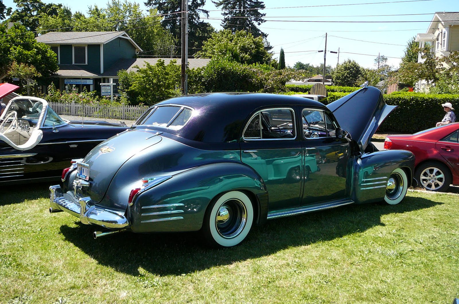
Many  towns across  Oregon sponsor annual Classic Car shows.  Being the lover of movies from the 30's and 40's that I am, I have been longing to visit one so when I read the ad for the show in Coburg, off we went.  We got up on a Saturday morning and drove the short distance to the middle of town where rows and rows of bright, shiny classic cars were lined up. 

Owners sat around on folding director's chairs under portable tents visiting with each other and waiting to answer questions and share stories with curious onlookers.  Under a tent children were sitting at table building models of classic cars from car kits.  Volunteers were serving  box lunches of chicken BBQ (which I've learned just means chicken cooked on a grill).  And later a 50's dance was planned for anyone who wanted to sport their poodle skirts and try their hand (foot) at the jitterbug.


 What fun!   I could just see myself, in one of these beauties, hair tied back with a lovely silk scarf, cruising the 101 (Pacific coast highway) with the top down...kind of like Grace Kelly in "It Takes a Thief". 


Yes, these are the cars that set the stage for many of those classic movie scenes I've grown to love.


As we strolled and ogled we listened to strains of the Beach Boys- how apropos....

    Well I'm not braggin' babe so don't put me down
    But I've got the fastest set of wheels in town
    When something comes up to me he don't even try
    Cause if (it) had a set of wings man I know she could fly
    She's my little deuce coupe
    You don't know what I got
    Little deuce coupe
    You don't know what I got

Surf's up y'all!!!

Tuesday, August 24, 2010

Agate Hunting

This time of year, as opening day of dove season approaches, the High family begin making their plans for the annual family gathering and hunt.  But this year I've discovered a new passion (not that dove hunting was ever an old passion in my book).....agate hunting.
You don't need your gun safety course certificate and you don't have to stop at Walmart to stock up on ammo for an agate hunt.  Just grab a grocery bag and your windbreaker (cause it's always windy on the Oregon coast) and head to the beach. 

Oregon's coastline is blessed with agates just waiting to be discovered.   Any season is agate season but for those willing to be patient, low tide is when the water slides back and treasures are revealed. 

Bullards Beach at Bandon, Oregon is the site of my first agate hunt. 


The beach buffers one side of the Coquille Light House built on the jetty where the Coquille River empties into the Pacific.


An agate is a "rock".  More specifically it is a variety of quartz, mainly chalcedony that is characterized by its fine grain and bright color. They are usually associated with volcanic rock (of which there is an abundance in this area of Oregon). 
Rocks are very plentiful on these beaches , more so than shells and the colors and patterns embedded in their hard surfaces are beautiful.  Now it remains to be seen whether or not I've discovered any agates in my rock collecting adventures. (I've not yet sprung for the handy dandy guide to Oregon gems).  I do know that the colors I see when the wave retreats from the beach bring me joy, consequently I've come home with bags of rocks to fill the bowl on the coffee table. 


When I look at each of these rocks and hold them in my hand looking at their unique pattern of color and design and feeling their smooth surfaces, I am reminded that their beauty has been uncovered because of time spent being tumbled by surf and smoothed by sand. What a life lesson there is in that.

Thursday, August 5, 2010

Coffee...nectar of the gods.

Coffee....
Love it.  Black and piping hot and so strong it reaches out of the cup and slaps you in the face...
Cold and creamy with that nutty flavor that calms you down and perks you up all in the same sip...
Frozen and straight from the ice cream carton- just me and  it and a spoon...
At the end of a meal with a dash of some luscious orange or almond flavored liqueur that turns it magically into "dessert in a cup".
Coffee is all these things and more.

As I've visited different areas of the country it's been interesting to observe all the ways in which coffee is presented and the esteem in which it is held.  
In Nashville you don't have to go to far to find a Starbucks or "Starbucks-type" coffee. My taste buds, just as many others, always found security in the chain type coffee houses.   In Columbia, there was no Starbucks to be found so  I tried several "baristas" who proved to be nothing more than wannabes. I did find one little coffee spot that seemed to have a nodding familiarity with how to do the brew and offered up a palatable alternative. 

But here in Oregon, well suffice it to say, the availability of premium coffee has risen to all new and enjoyable heights. Simply said, Oregon is proving to be coffee mecca.
I remember a colleague of mine telling me how his son, who had spent some time in the Northwest, on returning home was appalled at the absence of the independent barista and at John Q. Public's addiction to "chain" brands.  I gave him a quizzical look , being highly offended since I am Jane Q. Public.  But now...I get it. 

In the more populated areas of Oregon (of which there are only a few) you can certainly find the standard Starbuck's which always provide a taste you can count on and a comfy place to sit an compute.
But the supreme delight has been to discover so many independent baristas.  They come in many forms usually little free-standing, drive by kiosks out in a parking lot, but they can also be found in random places on the side of the road, in the middle of an industrial area or even just out in the middle of nowhere. I even spotted one on the sidewalk at the Jerry's (Home Depot type) store.  And, joyfully, all serve up a really great tasting brew.

I've learned that I can count on Oil Can Henry's as a compass for locating a cup of espresso. Oil Can Henry's is one of those quick oil change places.  Every location seems to have some type of coffee dispensary in its lot or attached to it's side.
One thing's for sure, in our travels up and over the back roads of the countryside and through the small towns  and wide-spots in the road of the mountains of Oregon, one thing holds true.  The sign may say "next gas- 50 miles"  but you can bet you're bottom dollar good coffee won't be that hard to find.
Ah, Oregon!!!  You are a people after my own heart!!


Below are of a few of the creative names and locations I've come come across.  There are many more but my husband's patience has rationed me to only so many  "Turn around...I need a picture of that cute little coffee place" kind of stops :)

    The Human Bean
    Supreme Bean
    Brewed Awakening
    Holy Grounds
    Nina's Pony Espresso
    Sweet Beans
    Caffeination Station


Tuesday, August 3, 2010

Lava Fields Forever

Everyone says we should see the lava fields.  I've seen the basaltic rock at the beaches but I've never ever heard of fields of lava.  So off we go toward the town of Sisters (named for the 3 Sisters Mountains) on the Old McKenzie Road.  The Old McKenzie is passable only in the summer months and isn't opened for action until July so... lucky us.
On the way we make a stop at Proxy Falls in the Deschutes National Forest.  I really don't know anything about these falls accept they are beautiful and fall from a height of 200 feet.   To get to them we had to cross over what was at one time a lava flow, kind of a trickle from the big deal.

You go through this dusty bleak area and then come into a green forest floor.  The climb down the the lower pool is kind of tricky but  it's worth it because when you get there you can sit on soft moss and feel the cool mist hitting your face refreshing and reviving you.


Back on the Old Mac, the trek to the lava fields changes drastically from the lush, verdant woods of the forest to what is still, after so many years, a barren, charred wilderness that stretches for miles and miles, really as far as you can see.


The structure above is called Dee Wright Observatory and is built entirely of the lava rock.
The observatory was built in the 1930's by the Civilian Conservation Corp.  By the way, the CCC (created by FDR to give people jobs after the Depression.  Hmmm.....what a novel idea!)  built a lot of things in this area.  Bridge after bridge on the coast highway was built by those folks.  Before that, every time you came to a river emptying into the ocean you had to take a ferry to get to the other side.  That wouldn't work out well for a Type A personality.

The bronze disk looks like a sundial but is kind of like a compass that points to all the surrounding mountain peaks. On a clear day you can see mountains from Portland to near Northern California. Inside the structure are little peepholes and when you stand right in front of one, the peak you are seeing is the one that is listed below the little window. This is really cool for me since I can't seem to figure out which mountain is what.  This area of the Cascade Mountain range has the highest concentration of snow capped volcanos in the lower 48 states. 


At the top of the observatory there are some bicycle guys who are celebrating with high-fives and slaps on the back  the wonderful feat they've just accomplished...the stuff that biking stories are made of they say.   They go on to tell everyone that they've just completed the long climb up this mountain with almost no water becoming very dehydrated and almost passing out when they got here. I'm finding it hard to understand when stupidity left off and the heroic accomplishment began.  Why would seasoned bikers (which I assume they are as they're wearing the spandex to prove it) embark on this kind of  ride without such an essential element?   I just wanna say...."Seriously...what were you thinking?"

All the black rock you see is the leftovers from the surrounding molten gushers.  The "snag" trees are look like silvery ghosts next to the immense blackness.
 The lava rocks are very hard to walk over and I'm amazed that this area could be  traversed with horses and wagons prior to the CCC's road work.

Saturday, July 31, 2010

The inspiration for Ocean Spray (not the kind you feel on your face)

I've always been intrigued with cranberry bogs.  Anyone who sat in my 5th grade science class over the years knows how I've longed to see one in real life.  There is something about all that pink-red color covering the water when the berries are afloat that is just lovely to look at.  Then on our way to the beachside town of  Bandon, I read that it is the "unofficial" cranberry capital of Oregon.  Surprising to note, Oregon contributes a considerable amount to the cranberry crop.  Hoping to see firsthand what I'd only seen in pictures, I stopped in at the Bandon tourist office to learn more.   The lady there really didn't know anything about the bogs location (don't really understand that as Bandon hosts a big Cranberry Festival every fall).  Not be deterred from my hunt for the berry, I did a bog search to locate one. Thanks to my husband's willingness to go along on this backroads trek, we finally found it .  It took some doing as the bogs didn't look anything like I had imagined.  They were big square pits, no floating beauties, just a mass of greenery.  We parked for a close-up view and found the pit was filled with a mass of vines that had  berries not fully ripe yet.  This piqued my curiosity and led to further investigation.


The cranberry is one of the few fruits that originated in this country.  It was first called "crane berry" because someone thought the way the fruit hangs from the vine resembled the look of a crane.  Bogs are depressions in the ground that are marshy so you will find cranberry bogs are going to be near water such as wetlands.  During growing season the cranberry bogs are drained of their water.  When it's time to harvest, the farmer floods the bogs so that the berries float. They do this because they have air pockets in them (remember that pop you hear when you boil the berries to make sauce?).  After they loosen from the vines, a big floating boom kind of "rounds up" the berries so they can be removed from the water. And that's  the part I'd really love to see.  During the growing season, farmers wear stilts to roam around their bogs.
To determine fruit goodness you bounce the berries.  The first guy to do this John Webb in 1880, would toss his berries down the steps and the ones that bounced were keepers.  As to the beautiful picture of the floating fruit on the Ocean Spray website?  Maybe in September.

Wednesday, July 28, 2010

Took a detour at Costco and ended up at Crater Lake

It's the 23rd of July. I started out today with a trip to Costco topping the "to do" list but lo and behold, I now find myself surrounded, not by masses of bargain shoppers, but by dark green mountainsides topped with snow covered peaks.  Ironically here in valley of all this cool, lush beauty is a barren flatland.

I reach down to pick up one of the many rocks that fill this valley floor. Anticipating the feel of its heaviness, as I lift it I'm surprised to find it light as a feather.   Pumice. Rocks peppered with multitudes of holes.  Left-overs from some ancient eruption. The area I now stand in is aptly called the Pumice Desert.  On the info plaque I read that one time pumice filled this spot to a depth of 100 feet, not the most fertile habitat for plant life. However, here and there the ashy desert is broken by an occasional brave sapling struggling to survive and clumps of a grassy like plants with little yellow flowers.   

This  pumice-filled landscape is the welcome mat for the entrance to Crater Lake. 
Crater Lake is exactly what its name states, a lake in a crater.  It is the lake that fills the top of Mount Mazama where that ancient volcano once erupted and then collapsed in on itself (caldera).  This isn't just any ole' lake you'll find no jet skis or catfish jumpin'. In fact Crater Lake forms a very striking contrast to the wasteland I just came through. In the spot where once boiled and churned molten hot lava, now rests a placid pristine body of water colored the most vivid, intense shade of indigo I've every seen outside of a doctored Polaroid pic. 
This body of water is the deepest in the US (1943 feet) and has been fed over the many years from precipitation and snowmelt. In the interior of the lake is a small black island shaped somewhat like a witch's hat and called Wizard Island.  It was formed from a second eruption.  Two for the price of one....kind of like a volcano in a volcano.  If you look through the binocs you can see the caldera at the top of it too. 

The rim of Crater Lake is paved so we can drive the entire perimeter, but only in the summer months.  This is one drive where you don't have to strain and keep saying "I wish I could see, I bet the view is great over there."  They have sprinkled many spots to park and snap all along the drive.   
The real treat (as if there was need for more) is the mountain lodge built on the south side of the rim.  Around dinner time the back porch is opened for viewers and fortuitously, I was in the right place at the right time to snag a couple of rockers.  Needless to say, it was really hard to drag myself away from that chair, that view, and and that special beverage of my choice to make the 3 hour drive back to Eugene. 
By far this "side trip" provided a  much more enjoyable way to spend my time than fighting the shoppers to the bargains at  Costco.

Wednesday, July 21, 2010

Cape Perpetua

I'm looking down a steep cliff side into the surging waters of the Pacific Ocean 800 feet below.


I'm trying to imagine being on the face of this cliff
                   ...on a trail merely 3 feet wide
                       in the winter
                       during a storm
                       crawling along on my belly
                       hanging onto my horses' tail...
to get the mail from Newport to Florence.

This was life in 1897 at Cape Perpetua.
  
By 1914 this narrow trail was widened to accommodate wagon travel.


Cape Perpetua's cliff is the highest headland on the Oregon coast.

I've been blessed with a clear day and can see 70 miles up and down the coast line and 37 miles out to sea.  The view I'm enjoying now came in mighty  handy in WWII.  After the Japanese bombed Mt. Emily in Brookings, Oregon( in hopes of weakening national resources by starting a forest fire) ,the rock shelter atop Cape Perpetua provided a great observation point for protecting this part of the  coastline.


Cape Perpetua is located in The Siluslaw National Forest.  This forest is full of old growth trees with a giant spruce that was just a sapling when Columbus discovered America. Walking down the trail takes me to another place and time.  One tree root looks like a sideways elephant.  The carpet of ferns are big enough to hide a fairyland underneath.


At the base of the cliffs,  puddled in the nooks and crannies of the black basalt rock, are tidal pools that teem with life at low tide.  I'm here at high tide and watch as those high tide waves slam against the rocks finding  places where erosion has worn holes through the rock surface.  The pressure of those waves causes water to explode through those holes like giant plumes from an active volcano.